
About Me

- Ric
- Florida, United States
- Bred, raised, educated and life long Floridian, and proud of it. E-mail at one(dot)legged(dot)old(dot)fat(dot)man(at)gmail(dot)com
Sunday, July 25, 2010


“I'm not afraid of facts, I welcome facts but a congeries of facts is not equivalent to an idea. This is the essential fallacy of the so-called "scientific" mind. People who mistake facts for ideas are incomplete thinkers; they are gossips.”
“Cynicism is not realistic and tough. It's unrealistic and kind of cowardly because it means you don't have to try.”
Monday: A 30 % chance of showers and thunderstorms after 8am. Mostly cloudy, with a high near 94. Calm wind becoming south between 4 and 7 mph.
Monday Night: A 20 % chance of showers and thunderstorms before 2am. Mostly cloudy, with a low around 73. South wind around 6 mph becoming calm.
Tuesday: A 40 % chance of showers and thunderstorms after 8am. Mostly cloudy, with a high near 94. Calm wind becoming west between 5 and 8 mph.
Tuesday Night: A 20 % chance of showers and thunderstorms. Partly cloudy, with a low around 73.
Wednesday: A 30 % chance of showers and thunderstorms. Mostly cloudy, with a high near 94.
Wednesday Night: A 20 % chance of showers and thunderstorms. Partly cloudy, with a low around 75.
Thursday: A 40 % chance of showers and thunderstorms. Mostly cloudy, with a high near 94.
Thursday Night: A 30 % chance of showers and thunderstorms. Partly cloudy, with a low around 75.
Friday: A 40 % chance of showers and thunderstorms. Mostly cloudy, with a high near 94.
Friday Night: A 30 % chance of showers and thunderstorms. Partly cloudy, with a low around 76.
Above normal high temperatures in the mid 90s each day will continue to push heat index into the 100 to 105 degree range each afternoon.
Scattered thunderstorms are expected each day. the stronger storms will be capable of frequent lightning and gusty winds.
Monday, mean layer ridge shifts over the area with slightly drier air aloft moving in. Expecting mainly diurnal storms with best coverage over the inland areas where the sea breezes merge. The GFS brings in a middle level impulse during the afternoon which will help enhance storms and may see a few strong storms with frequent lightning and strong winds.
Tuesday, mean layer ridge shifts south of the area as a trough of low pressure forms across the middle Atlantic. The West Coast sea breeze will be the most active and will probably merge with the East Coast sea breeze near or east of the I-95 corridor. Convection will be diurnal in nature and will form along the sea breezes. Have gone with scattered probability of precipitation area wide. Precipitable waters increase to around 2 inches and with daytime heating and instability could see strong storms with frequent lightning and strong winds.
Upper high will retrograde as a trough of low pressure digs over New England. This will allow front to sag a bit closer to our north zones and increase southwest surface flow. As a result probability of precipitation will increase a bit with better chances of rain over east areas. Temperatures will remain several degrees above normal this week.
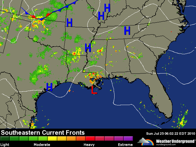
Weather Underground

..HOT THROUGH THE PERIOD WITH HEAT INDEX 100-105 DEGREES...
..SCATTERED STORMS TODAY.. | |
 | |


Today: Partly cloudy. Patchy fog early in the morning. Chance of showers and thunderstorms in the afternoon. Highs in the mid 90s. Southeast winds 5 to 10 mph. Chance of rain 40 %. Heat index readings 103 to 107.
Tonight: Partly cloudy. A 30 % chance of showers and thunderstorms in the evening. Patchy fog after midnight. Lows in the lower 70s. South winds 5 mph.
Scattered showers and thunderstorms are expected today with most of the activity across the inland areas this afternoon. Frequent lightning and gusty winds will be the main concerns with the stronger storms.
Highs in the mid 90s inland and near 90 at the coast this afternoon will push heat index into the 100 to 105 degree range. Use extra caution while outside today.
There will be a continued elevated risk of rip currents at the area beaches due to a lingering swell.
Forecast Details: mean layer ridge north of the area moves south the next few days and will be south of the area by Tuesday.
Plenty of moisture and instability for scattered storms to form. With mean ridge north of the area, expecting scattered showers/isolated storms to form near the coast by late morning and early afternoon and spreading inland during the afternoon/early evening. Best coverage along I-75 corridor where highest probability of precipitation will be. Warm temperatures aloft/weak middle level lapse rates should help limit severe potential but strong low level lapse rates (from heating) may produce a few strong storms with frequent lightning and gusty winds.
Today's Pollen Levels: 4.0 Low Medium (on s a scale to 12); Predominate Pollen: Grass.
For additional information visit the National Weather Service in Jacksonville website on the internet at http://www.srh.noaa.gov/jax/
Saturday, July 24, 2010

India's $35 tablet--how low can it go?
By Leslie Katz
India on Thursday unveiled a prototype tablet computer that would sell for a mere 1,500 rupees, or $35, with the price possibly dropping even further as R&D efforts continue.
Kapil Sibal, the country's Minister for Human Resource Development, showed off the super-cheap touch-screen device in New Delhi as part of a push to provide high-quality education to students across the country. The tablet also comes with a solar-power option that could make it more feasible for rural areas.
The Linux-based computer at first glance resembles an Apple iPad and features basic functions you'd expect to see in a tablet--a Web browser, multimedia player, PDF reader, Wi-Fi, and video conferencing ability. It has 2GB of RAM (but no hard disk, instead using a memory card) and USB ports and could be available to kids from primary school up to the university level as early as next year.
Students from several branches of the Indian Institute of Technology co-designed motherboards for the computer, which the ministry would like to see dropping to $20 and possibly getting as low as $10.
Sibal called the as-yet-unnamed device India's answer to MIT's famed OLPC laptop aimed at children in developing nations, which started off five years ago with a projected cost of $100, but ended up going for $200. In May, Marvell Technologies announced that it would partner with the OLPC foundation to create the hardware for a proposed OLPC tablet, currently named the XO-3, that would go for around $100.
But while the extremely low price of India's newly unveiled tablet is generating much hoopla, the gadget still faces hurdles before it lands in the public's hands.
"This is just a prototype," education expert Zubin Malhotra told Newsxlive. "We need to find people who will be able to manufacture these devices at these price points and continue to develop them going forward."
The tablet is part of a larger initiative aimed at improving India's educational system through technology. Nearly 8,500 colleges in the country have already gotten broadband connectivity, according to the Ministry for Human Resource Development, and some 500 Web-based and video courses are available for upload on YouTube and other online portals, with more in the works.
India unveils a prototype for a super-cheap tablet aimed at students. But will it really cost that little once it moves past the R&D stage?

A new priority of the U.S. Department of Transportation is an age-old idea: Transport freight by ship for as long as possible. The DOT is proposing designated shipping channels known as Marine Highways, and one may be leading to a port near you.
If you’ve purchased any household goods in the United States recently, they probably took a familiar path from the factory to the store where you bought them: to North America on a massive cargo ship, from the ship to a railway, and finally from the rail yard to your local retailer by truck. In many cases, freight is carried solely by truck along interstate highways.
Unfortunately, such a system is far from efficient. It clogs our highways with multiple trucks headed in the same direction and brings pollution into our cities near freight terminals.
That’s why the Maritime Administration (MARAD) has proposed a system of marine highways where ships would transit goods within the United States. Along designated corridors, ships could provide safe, environmentally friendly and reasonably quick freight transit among a network of well-situated ports.
According to MARAD Administrator Dave Matsuda, the United States is catching up with the rest of the world when it comes to marine highways. Also known as short sea shipping, coastal trade or coastal shipping, the rivers and seas of Europe and Asia are filled with small container vessels carrying cargo within a continent.
“This is an idea that’s been around for awhile,” Matsuda said. “The Europeans do it, and other folks do it. For about 10 years now people have been kicking the idea around in the maritime community. It’s to the point that it’s been joked about that the Marine Highway conference has become a cottage industry.”
When we caught up with him, Matsuda had just been sworn in as MARAD administrator. Earlier this month, he announced an initial $7 million (.pdf) in grant funding for marine-highway projects that would primarily strengthen existing projects and proposals.
Some short sea shipping operations are already moving freight in the United States, and Matsuda wants to help them expand. “These are the experts, these are people who have started up new markets in the past,” he said. “They know the industry, they know the people and the operations.”
Matsuda is clear about engaging existing operators. “The government’s role here is really to help promote these and get them up and running,” he said. “We can talk to local transportation planners and say, ‘Hey, here are some of the federal programs that help.’ There’s a limited amount of federal dollars to put towards buying cranes or barges or fixing up a port or something that we need to have up and running.”
Some projects are economic no-brainers, such as moving overweight or hazardous materials, where the cost of obtaining road permits would be prohibitive for truck shipments. In most cases, however, in order for a project to make sense and for shippers to make money, MARAD must identify corridors with strong two-way traffic so empty ships don’t ply the waters.
A good example of such a project is a proposed Green Trade Corridor in California, a project funded by $30 million of TIGER funds that connects the inland agricultural areas and the Port of Oakland by a marine highway.
Currently, goods from Asia come into the port of Oakland and are trucked across the state while agricultural products are trucked in the opposite direction. “It’s a tax on commuters, and it adds to the congestion, beats up the bridges and raises the cost of maintaining infrastructure,” said Matsuda. “It’s not just getting the trucks off the road, but also putting people to work in some of these areas that are really devastated.”
A marine highway would move some of that traffic onto barges and guarantee two-way traffic for the company operating the barges.
A Rising Tide Lifts All Boats, Trains and Trucks
A project that promises to put people to work shouldn’t put others out of work. Marine highways will change rather than replace rail and truck shipments, so they seem to have gained support from groups that represent competing modes of transit.
“Marine and rail freight have co-existed since the 1830s when the rail industry began, said Holly Arthur, a representative for the Association of American Railroads. “While shipping via water can be seen as competition, it also is a significant customer segment for railroads.”
According to Arthur, intermodal transport — the movement of shipping containers by multiple methods, such as from ship to rail — represents 21 percent of rail revenue in the United States, a figure that is continuing to grow. If boat traffic increases, the rail industry stands to benefit.
Boats can’t usually pull up to a factory loading dock or back into the parking lot of your local big-box store, so trucks are safe, too. “At the end of the day, your shipment winds up at a port, so it has to go on a truck,” said Matsuda. In addition, boats tend to travel more slowly than trucks (though they usually don’t have to stop overnight for rest). Often, short sea shipping services run on a weekly schedule and, said Matsuda, “It’s hard to sell a weekly service when you’re dealing with folks who need things a little more quickly.”
In a country where the majority of freight travels along marine highways, Matsuda envisions some long-haul truckers working instead in freight yards or in regional distribution, while others remain on the roads with cargo that can’t wait for a slower-moving boat. If estimates of 70 percent growth in the freight industry over the next 10 years are accurate, trucks will always be in high demand.
According to Matsuda, the U.S. DOT chose to refer to the project as Marine Highways rather than short sea shipping because the network of waterways would often be parallel to an existing interstate highway. “We wanted to draw a parallel with the interstate system, if you can draw a highway on a map, that you can draw a waterway along the map — maybe M-95 — and it’ll get you to the same place,” he said.
One kind of freight that Matsuda thinks is best suited for the water is hazardous material. “With hazardous materials, we only see an upside for getting them out of populated areas,” he said. While a lot of bulk hazmat cargo is shipped, that which fits into a container is still largely transported on packed highways. “Anything we can get off the highway is obviously a benefit, if it makes sense to do,” he said. “It’s less gas per mile, but it also helps the people on the roads.”
Better for the Environment
In addition to transporting hazardous materials outside of populated areas, a clear advantage of short sea shipping is the reduced environmental impact of moving freight on ships.
According to Carrie Denning, a researcher at the Environmental Defense Fund who coauthored the report The Good Haul: Freight Innovations for the 21st Century, a shipping company that moves containers by sea between Port Manatee, Florida, and Brownsville, Texas, already saves 70,000 gallons of fuel on each one-way voyage compared to a comparable truck journey.
Those fuel savings translate into fewer emissions in population centers. “One way to reduce pollution emissions in some regions will be to substitute multiple truck trips with single barge trips via coastal shipping routes that meet robust environmental performance standards,” she said.
Even with the obvious fuel savings, Denning says that marine routes could still pose serious environmental consequences. Ports themselves are notorious for high levels of emissions from machinery used to move freight. To truly be environmentally responsible, ports along a marine highway would have to implement solutions such as electric forklifts and yard trucks — many of which are already in place at the Port of Los Angeles.
Additionally, highways would have to be designated clear of environmentally sensitive areas. “Coastal shipping is not a panacea,” she said. “Depending on the highway route, there could be serious ramifications for marine life if dredging is required, if migratory patterns are disrupted, or if additional infrastructure is needed that interferes with certain marine ecosystems.”
RoRo Your Boat
A centerpiece of the European short sea shipping industry is a small freighter known as a RoRo, short for “roll on, roll off.” While larger ships require cranes to lift containers onboard, RoRos pull straight up to a dock where trucks can drive onboard and unload freight containers. Because they’re smaller, they don’t require channels as deep as larger ships, and can minimize the need for dredging.
“The ship literally pulls up, lays down a ramp and the trucks drive on and off it,” said Matsuda. “From an operating standpoint, you don’t need cranes, you don’t need to pay the skilled workers — but you need people to drive the trucks on and off the ship.”
Rather than investing in the installation of cranes and other equipment at small ports, Matsuda says that RoRos could follow what he calls the “Southwest Airlines model,” after the carrier that started off flying into secondary airports. Smaller RoRos could bypass major ports and travel through shallower waterways to inland cities.
Matsuda just saw such a system in action at the Port of Rotterdam in the Netherlands. “It is just incredible to see these relatively small, long, thin, self-propelled ships that can carry 20 or 30 containers that kind of zip around in this massive port after the giant container ship has been offloaded,” he said. “They go up the rivers into Europe or around the coast to other ports.”
Would such a system be possible in the United States? There may not be a choice. With roadways in major cities already crammed with freight traffic and the demand for freight ever increasing, putting freight on the water may be the most sensible solution for companies that need to move goods from here to there. Matsuda says a political climate that’s focused on creating jobs and helping the environment also will support the cause.
“Where there are corridors, the federal government will help focus attention and investments to get those services up and running,” he said. “This is something that we think is going to go a long way.”
Read More http://www.wired.com/autopia/2010/07/dot-turns-underused-waterways-into-marine-highways/#ixzz0ubxiVlD5


On this date1840 sixteen enlisted men, under the command of Sergeant C. O. Williams, were attacked by Indians on the Wekiva River, Florida.
In 1928 Stuart Bank and Trust Company failed to open its doors, a victim of the “bust” and the failure of the Bankers Trust of Atlanta, its primary fiscal agents.
In 1931 City of Miami Shores was re-named the City of North Miami.
In 1951 Bumper 8, a captured German V-2 rocket mated with a United States Army WAC Corporal rocket, was launched from Cape Canaveral, thus inaugurating the Space Program at what would become the Free World’s largest testing ground for space exploration.
In 1956 Honeywell Aerospace, a major Florida technology company, was founded in St. Petersburg.

Weather Underground
...SCATTERED STORMS TODAY...
| |
| |
Today: Partly cloudy. Chance of showers and isolated thunderstorms in the morning then showers and thunderstorms likely in the afternoon. Highs in the lower 90s. Southeast winds 5 to 10 mph. Chance of rain 60 %. Heat index readings 100 to 104.
Tonight: Partly cloudy. A 20 % chance of showers and thunderstorms in the evening. Lows in the mid 70s. Southeast winds 5 mph
Scattered showers and thunderstorms are expected area wide today. Most of the activity will be across the inland areas this afternoon. Frequent lightning and gusty winds will be the main concerns with the stronger storms.
Highs in the mid 90s inland and near 90 at the coast this afternoon will push heat index into the 100 to 105 degree range. Use extra caution while outside today.
Forecast Details: .mean layer (1000-500 MB)ridge axis will remain north of the area through the period. Tropical Depression Bonnie across the east central Gulf will continue to move west-northwest and is forecast to move ashore the central Gulf Coast tonight. An upper low will pass well south of the area sun followed by another one Monday. Coastal trough off the northeast Florida/southeast Georgia coast combines with a middle level impulse to produce scattered showers/isolated storms along the coast this morning which will spread inland this afternoon. Radar already showing isolated showers offshore moving northwest. Temperatures aloft warm but enough moisture (PW around 2 inches) and instability (Li -3 to -4) to produce a few strong storms inland during the afternoon. The trend for Sunday will be for scattered late night and early morning showers near the coast and scattered storms inland in the afternoon.
Today's Pollen Levels: 4.2 Low Medium (on s a scale to 12); Predominate Pollen: Grass.
For additional information visit the National Weather Service in Jacksonville website on the internet at http://www.srh.noaa.gov/jax/
Friday, July 23, 2010


On this day in 1836 Seminole Indians attacked the Cape Florida lighthouse on Key Biscayne. Assistant keeper, John W. B. Thompson, and a slave returned fire until evening. The two men were wounded and the slave died. The Seminoles set the lighthouse afire, and when a large drum of oil was punctured, the entire building appears ready to burn. Thompson retreated to the top of the lighthouse to escape the flames. In desperation, he throws a keg of gunpowder to the bottom of the tower. The explosion rattled the building, momentarily suppressing the fire. The Seminoles were convinced that both men were dead and withdrew. Thompson managed to survive, although he was badly burned by the fire. He was rescued a few days later by the crew of the U.S.S. Motto, whose crew had heard the explosion although they were about twelve miles at sea.
In 1839 One enlisted man was killed when Seminoles attacked a column of the 2nd Dragoons, commanded by Colonel D. E. Twiggs, on the Caloosahatchee River, seven miles from Charlotte Harbor.
In 1917 Congregation Beth-David, Miami’s oldest Jewish congregation (begun in 1913 as B’nai Zion), was chartered.

At 800 am EDT the center of Tropical Storm Bonnie was located near latitude 24.7 north, longitude 79.8 west. Bonnie is moving rapidly toward the west-northwest near 19 mph. This motion is expected to continue during the next day or so. On the forecast track Bonnie is expected to move over the southern Florida Peninsula later today and move over the eastern Gulf of Mexico tonight and Saturday. Bonnie is forecast to approach the northern Gulf Coast late Saturday or early Sunday.
Maximum sustained winds remain near 40 mph with higher gusts in a small area north and east of the center. No significant change in strength is expected before Bonnie moves over South Florida. However, some slight strengthening is possible when the cyclone moves over the Gulf of Mexico on Saturday.
Tropical storm force winds extend outward up to 85 miles mainly to the north and east of the center. Latest minimum central pressure reported by an Air Force plane was 29.77 inches.
Subscribe to:
Posts (Atom)